Sperryville · Rappahannock County, Virginia Peak color, the slow way.
Color starts up on the ridge and works its way down into the hollows. Take the high road along Skyline Drive, the low roads through the orchards, or both — and leave time to stop.
Up on the ridge: Skyline Drive
Shenandoah National Park
From Sperryville, take US-211 west about 7 miles (15 min), climbing from about 690 ft to the Thornton Gap entrance at mile 31.5, about 2,300 ft up. $30 per car, good for 7 days. No cash — card or mobile pay. The limit is 35 mph, and you’ll want every minute of it.
Road and trail conditions: nps.gov/shen
| Mile | Overlook | Looks |
|---|---|---|
| 32.9 | Buck Hollow | east-northeast |
| 33.0 | Hazel Mountain | southeast |
| 35.1 | Pinnacles | south, Old Rag in view |
| 36.4 | Jewell Hollow | north-northwest, the valley |
| 38.6 | Stony Man Overlook | |
| — | Thorofare Mountain | east; highest overlook in the park |
Stony Man
Mile 41.7 · 1.6 mi round trip · easiest
About an hour and 340 ft of climb from the Stony Man parking area, out to views over the Shenandoah Valley and Massanutten Mountain.
Mary’s Rock
Mile 33.5 · 2.9 mi round trip · moderate
From Meadow Spring parking (the trail starts across the Drive). About 3 hours and 830 ft of climb. The lot is small — go early.
Hiking Old Rag? You need a $2 day-use ticket per person, bought ahead on Recreation.gov or at 877-444-6777 — none are sold at the trailhead — plus the park entrance pass. Conditions: nps.gov/shen · (540) 999-3500
Three stops in Sperryville
Hours for Sat 10/24 & Sun 10/25
Rising Water Brewing
12018 Lee Hwy — the green annex at the Sperryville Schoolhouse
A rotating tap list in the middle of the village. Dogs are welcome, and you can bring your own food.
Sat 11–8 · Sun 1–6
Today’s updates: Instagram
F.T. Valley Farm
513 F.T. Valley Rd (Rt. 231) — about 6½ miles south
Fresh-pressed cider, cider donuts, a pumpkin patch, and Kilby Creek hard cider made from their apples. Live music Sat 10/24, 12–2. A short apple crop after a spring freeze; pick-your-own may be running — call first.
Thu–Sun 10–5
Hopkins Ordinary
47 Main Street, in the village
A bed & breakfast with its own cellar brewery in the original 1820s basement. Take a glass out to the biergarten, or sit by the fire.
Brewery Sat 1–7 · Sun 3–7
Today’s updates: Instagram
Back roads to wind along
Start in Sperryville
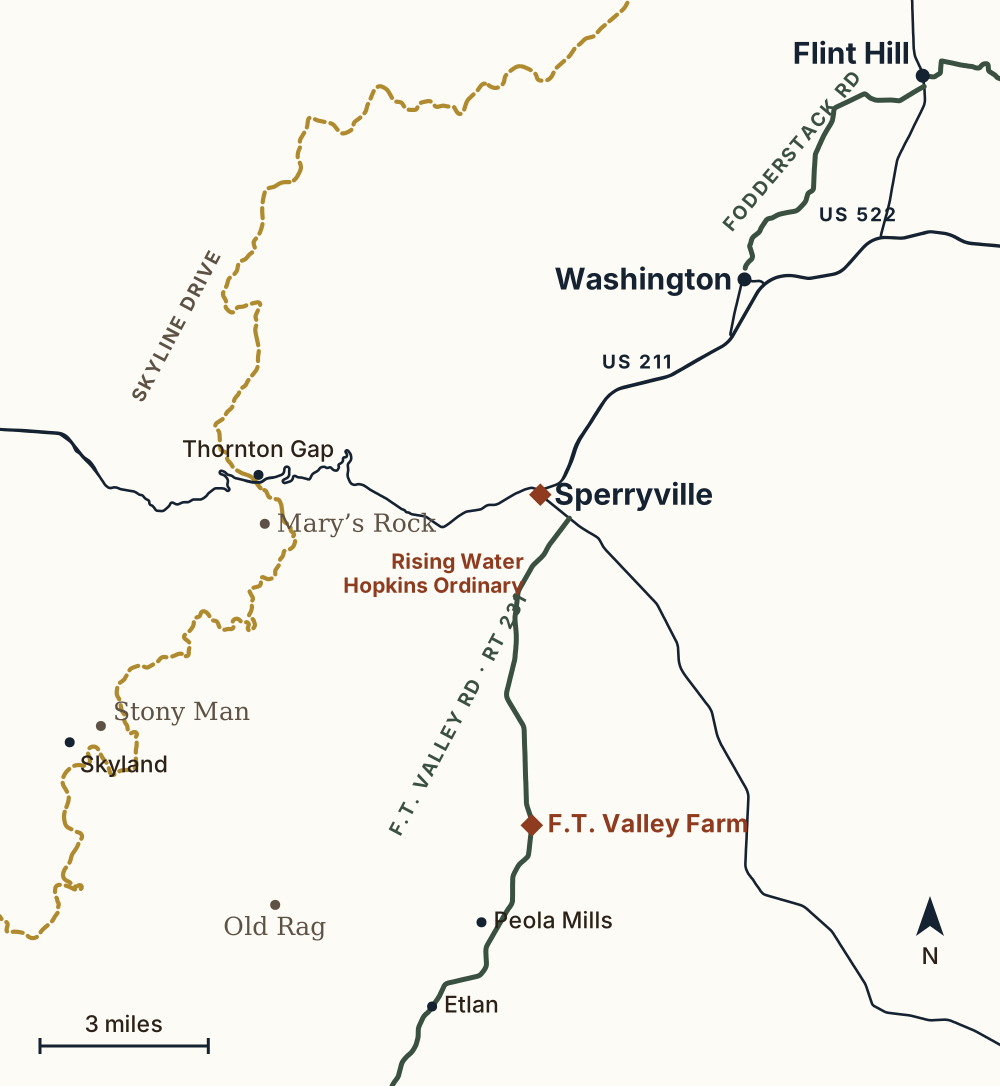
- Virginia Byway
- Skyline Drive
- US routes
- Featured stop
1F.T. Valley Road, south
Rt. 231 · Virginia Byway · Etlan & back ~21 mi
Leaves US-522 just south of town and runs along the foot of the Blue Ridge through Etlan toward Banco. The “F.T.” is Francis Thornton — the same Thornton as Thornton Gap. F.T. Valley Farm is 6½ miles down, on your way. Etlan and back is about 35 minutes; go on to Banco and it’s about 33 miles and 50 minutes round trip.
2Washington & Flint Hill loop
~24 mi · ~45 min before stops
US-211 east about 6 miles to Washington. From Main Street, pick up Fodderstack Road — part of a Virginia Byway — northeast through the farms to Flint Hill, then come home on US-522.
3Up to Thornton Gap
US-211 west · ~7 mi · ~15 min
The climb itself is the drive: about 1,600 feet from the village to the gap, where Skyline Drive crosses. Turn around there, or keep going onto the ridge.
Go slow
These are narrow country roads. To look or take a picture, pull fully off the road — never stop in a lane.
Before you lose signal
Cell service can drop in the hollows and at Old Rag. Load your route before you leave the village.
Call ahead
Hours and color both change week to week. Everything here was checked on Oct 20, 2026 — a quick call is still the surest bet.
Last checked Oct 20, 2026